
[NB. The reader will probably find it easier to understand this page if he or she has already acquainted himself or herself with the contents of Chapters 1 and 2. Chapter 1 concerns the basic building-blocks used in Romano-British place-names and Chapter 2 explains how those building blocks were assembled by the Celts to form compound names.]
Chapter 8
The Trajanic frontier between Tyne and Solway
1 In this chapter we will discuss Ravenna’s names Serduno (143) to Maia Fanococidi (154,155), and it is an article of faith that these are the names of forts on Hadrian’s Wall, i.e. the names of forts which were originally built astride or behind the Wall when the latter was built. But the names themselves tell a different story. We will consider them one at a time.
1.1 The name Serduno is normally considered to be an erroneous spelling of the Notitia Dignitatum’s Segeduno at Wallsend. But it need not be an erroneous spelling. The s and r of Serduno might both be hill-letters, so Serduno might in fact be the original Celtic name of the fort at Wallsend.
1.2 The next name to discuss is one which is not actually in Ravenna but is included in the Notitia Dignitatum - Pons Aelius at Newcastle. Now, if the compiler of Ravenna had used a Hadrianic map it would surely have been an unforgiveable affront to the emperor Hadrian, on the part of those who drafted the map, not to include on the map the name of the one fort which actually bore Hadrian’s family name – Pons Aelius at Newcastle. It has been argued that this fort was perhaps small and relatively unimportant and so was not worth mentioning in Ravenna. But if it was worth mentioning in the Notitia Dignitatum it was surely worth mentioning in Ravenna. The fact that it is not mentioned suggests that the name did not appear on the map used by the compiler of Ravenna, and it did not appear on the map because it did not exist at the date when the map was prepared. In other words the map predates the Hadrianic period. This suggests that Pons Aelius at Newcastle was a Hadrianic addition to an already existing fort system. No doubt it was built to guard the new bridge across the river Tyne.
1.3 The next name is Condecor (144) at Benwell. This is a straightforward old-style name in the hill-letters n and r. The cond element means ‘steep hill summit’ and cor means ‘steep hill’. The name as a whole thus refers to the location of the fort at the top of the steep escarpment on the north side of the river Tyne.
1.4 After Condecor comes Vindovala (145) at Rudchester. This name may originally have been Bindobala, a straightforward old-style compound in the hill-letters n and l. The bind element means ‘high hill summit’ and bal means ‘high hill’. Alternatively the name may originally have been Vintovala, where the inversion-type elements Vint and val respectively mean ‘slope of hill high’ and ‘slope of hill’. The name appears to have been transferred to Rudchester from the Horsley area, some two kilometres to the southwest. There there are the remains of a defended settlement on the summit of a high hill, thus suitable for the name Bindobala, and of a hillfort lower down the hillside, thus suitable for Vintovala.
1.5 Next comes Onno (146) at Halton. The fort appears from the map to have been built on top of a ridge where the ground falls away to the north and south but actually rises to the east and west of the fort. The spelling of the name cannot be right. It would appear that the second n was originally some other letter and that a letter is missing from the front of the name. Given the local topography it is probable that the original spelling was Condo meaning ‘steep hill summit’, perhaps referring more specifically to the ravine to the west of the fort. The nn of Ravenna’s Onno survived in the form Hunno in the Notitia Dignitatum, but the initial C of the original name, which is missing in Ravenna, changed to H.
1.6 Next comes Celunno (147) at Chesters on the North Tyne. Again, as in Onno, the double n should be suspect, since doubled consonants are rare in the earliest forms of Romano-British place-names. In this case we are fortunate since Ravenna itself gives with Celovion (178) the earlier name of the Chesters fort. The celov element appears to be an old-style element meaning ‘steep hill slope’. It is a name of the banna-type but using the hill-letter l rather than n and using the adjectival c meaning ‘steep’ rather than b meaning ‘high’. And indeed the fort is built on a steep-sided hill, though on the gentler lower slope near the river rather than on the steeper slope higher up. Presumably Celovion changed first to Celonion and the latter then changed to Celunno (147). But Celovion appears within a group of names which appear to be early, most probably Flavian. The other names of the group are Coritiotar at Corbridge, Ebio at Ebchester and Abisson at Durham, and it is to be noted that Chesters, Corbridge, Ebchester and Durham are in fact aligned with one another, this suggesting that the sites for the forts were selected and the forts built before the road-builders arrived in that part of the country. For this is hilly country, and if the forts had been built after the road then one would expect the forts to be spaced apart at convenient points along the road – they would surely not be aligned with one another. But Dere Street, which calls at Ebchester and Corbridge, but not at Durham or Chesters, is believed to have been built before Agricola marched his troops north into Scotland. We are therefore looking at a date prior to AD79 for the construction of Celovion, presumably the first fort at Chesters. Celunno is later, and may well have been Trajanic if the Chesters fort was re-occupied when Trajan abandoned the forts in Scotland (assuming it had been abandoned when Agricola left for Scotland).
1.7 After Chesters comes Brocoliti (148) at Carrawburgh. This name appears to comprise the transitional element broc, meaning ‘high hill steep’, and the inversion-type element lit, meaning ‘hill high’.
1.8 We move on now to Velurcion (149) at Housesteads. The spelling of the name would appear to be correct. The name combines the inversion-type element vel meaning ‘slope of a hill’ and the inversion-type element urc meaning ‘hill steep’. The name suggests that the first fort at Housesteads did not extend onto the summit of the hill, but was on the slope, which is certainly steep! The better-known name Vercovicium is later in date and is a simplification of Velurcionvicus. If one rewrites this as Ve [lu] rc [i] o [n] vicus and then deletes the letters in brackets one has Vercovicus, which is of course in essence the same name as Vercovicium. But the inclusion of the word vicus in the name suggests that the name was coined after the military had abandoned the site, perhaps when the Antonine Wall was built. Apparently the vicus to the south of the visible fort is bounded by ditches on its east and west sides. Perhaps one should look to see whether those ditches might have belonged to an earlier fort built south of the existing fort, i.e. on the slope!
1.9 After Velurcion comes Esica (150) at Great Chesters. This name has long puzzled scholars, but it is most probably just a name of the isca-type, referring to the fact that the fort is built adjacent a steep slope. The ground drops down to a stream on the north side of the fort and there is a slope to the south. This slope is not dramatically steep, but the description ‘steep slope’ is nonetheless not wrong. There are four ditches on the west side of the fort, which seems rather excessive for a fort in the military zone between the Wall and the Vallum. But they would not have been excessive for a free-standing fort on the same site. In addition, the Wall forms the northern wall of the fort and the northeast and northwest corners of the fort are curved, whereas it might have been easier to make the east and west walls of the fort meet the Wall at right angles. These two points, four ditches and rounded fort corners, might suggest that the Hadrianic fort stands right on top of a predecessor fort. (But see Chapter 20: 'Rome's frontiers in northern England' for further discussion of Brocoliti, Velurcion and Esica).
1.10 And, now, with Banna (151) we reach one of the two names which appear to discount the possibility that Ravenna’s names Serduno to Maia Fanococidi define the Hadrianic frontier. For Banna was originally Banva, and this is an old-style name meaning ‘high hill slope’. Such a definition is wholly inappropriate for Birdoswald, which is built on flat ground at the top of a high, steep escarpment on the north side of the river Irthing. We can thus reject Hassall’s proposed revision of the Notitia Dignitatum, which proposal was specifically made in order to place Banna at Birdoswald. Carvoran is known to have been Magnis and Bewcastle is too far away to be included in a list of forts along the line of Hadrian’s Wall. There is only one fort available to have been Banna and that is the fortlet at Throp, built on a hillside just north of the Stanegate. The association with the Stanegate may explain the function of Throp – it may have collected supplies for Birdoswald (see next-following paragraph) and there may have been stationed there a small contingent of troops charged with the function of supplementing the supplies delivered by road by hunting deer or whatever other wild animals were available in the neighbourhood. These troops will have been the venatores Banniess referred to on an altar found at Birdoswald (RIB 1905). They may have been a detachment of the troops stationed at Birdoswald, so it is not in the least surprising that they should set up an altar in their headquarters fort. But when the Wall was built, and assuming we are right in believing that according to the original plan the troops were to be garrisoned in forts to the south of the Wall rather than in forts on the Wall itself, then the fort at Birdoswald will have been abandoned, perhaps even dismantled. Banna then lost its function as a supply depot for the Birdoswald fort and so the fortlet was abandoned. Note that Collingwood indicated that Throp was abandoned about AD120-122 (Collingwood 1921), a little earlier than the date discussed above. It thus seems abundantly clear that Banna at Throp predates Hadrian’s Wall and so, by implication, all of the names Serduno to Maia Fanococidi predate Hadrian’s Wall.
1.11 We need now to discuss a name which does not actually appear at this point in Ravenna, but appears earlier as Gabaglanda (131), the fort at Birdoswald. Gabaglanda shows the common confusion of c and g and the fairly common omission of the letter m during medieval copying. The name will have been Cambaglanda originally, this being an old-style name in the three elements cam meaning ‘steep hill’, bagl meaning ‘high, steep hill’ and and meaning ‘hill summit’. The name is thus a precise and correct topographical description of the location of the Birdoswald fort at the top of the high, steep escarpment on the north bank of the river Irthing. But Gabaglanda appears in Ravenna’s list within a group of forts which are known to be Flavian, these being Bereda (128) at Plumpton Wall, Lagubalium (129) at Carlisle, Magnis (130) at Carvoran and Vindolande (132) at Chesterholm. It is thus perfectly reasonable to assume that Gabaglanda was also a Flavian fort. It can thus be seen that the fort at Birdoswald, like that at Chesters on the North Tyne, was actually founded some forty years before Hadrian’s Wall was built. The Flavian fort at Birdoswald may have been abandoned when Agricola marched north into Scotland and may then have been rebuilt to form part of the Trajanic frontier when the Romans abandoned the forts in Scotland.
1.12 Next comes Uxelludamo (152) at Castlesteads. Doubled consonants are rare in the earliest forms of Romano-British place-names, so the ll of this name was presumably originally some other letter-combination, with ld appearing the most likely. This would yield a name Ucseldudamo, where the ucs element means 'steep hill', eld means 'hill-summit' and damo is a duno-type element, but using the hill-letter m rather than n. The name thus refers to the location of the Castlesteads fort on the summit of a steep hill. The fort stands about 300 metres south of Hadrian’s Wall. Now, if the fort had been a Hadrianic foundation it would have been perfectly possible to build it on the Wall itself, perhaps nearer to Walton. It would not then have been necessary to divert the Vallum to the south at Castlesteads so as to dig it round the summit of a steep hill! These points rather suggest that the fort at Castlesteads was there before the Wall.
1.13 Now we come to Carlisle and Stanwix. Quite regardless of whether the Ravenna names Serduno to Maia Fanococidi define the Trajanic or the Hadrianic frontier the fort at Carlisle/Stanwix was called Lagubalium. The Flavian fort at Carlisle will simply have been relocated to the other side of the river Eden after Hadrian’s Wall was built in order to ensure that the troops were on the military side of the Vallum. Lagubalium is not mentioned at this point in Ravenna since it had been listed earlier within a group of Flavian forts. The fort at Carlisle, being located on the main western route into Scotland, and at a major river crossing, presumably remained in use right through the Flavian occupation of Scotland and later formed part of the Trajanic frontier.
1.14 The next Ravenna name is Avalava (153), normally taken to be the fort at Burgh-by-Sands. The better-known form of the name of this fort is Aballava, as confirmed by an inscription found at Burgh-by-Sands. But the inscription is dated to around AD255, which is much later than the period discussed in this chapter. However, no matter whether the original name was Avalava or Aballava the name seems inappropriate for the Wall-fort at Burgh-by-Sands, since the element val means ‘side of hill’ and bal means ‘high hill’. It would appear, then, that the original fort Avalava/Aballava was somewhere else and that the name was simply transferred to the Wall-fort when this was built. And in fact there are two other forts just south of Burgh-by-Sands. The first is known as Burgh-by-Sands I and is located at NY324582. It stands on the top of raised ground offering a commanding view (thus suitable for Aballava but not Avalava), and is thought to be early Hadrianic. The second is called Burgh-by-Sands III and is located at NY317587. This fort appears to stand on a gentle slope dropping down from the SW to the NE. The fort is not at the highest point of the slope, so the name Avalava appears topographically correct. But, as noted above, the name Avalava is not appropriate for Burgh-by-Sands I. Presumably, then, the earliest fort was Burgh-by-Sands III and this was replaced in the early Hadrianic period by Burgh-by-Sands I, which will have been one of the line of forts strung out from one side of the country to the other to the south of Hadrian’s Wall in the original design. Later, when it was decided to garrison the troops in forts actually built on the line of the Wall, Burgh-by-Sands I will have been replaced by Burgh-by-Sands II, lying under the modern village of Burgh-by-Sands. If the above reasoning is correct, then Burgh-by-Sands III will have been Ravenna’s Avalava and was most likely a Trajanic fort. What is not clear is at what time the first v of Avalava switched to b, though this was evidently before AD255, bearing in mind the inscription referred to above.
1.15 That only leaves Maia Fanococidi to consider, but before discussing that name we need to look at the Congavata of the Notitia Dignitatum. This name has long puzzled scholars, but with the minor and common change of v to n, and bearing in mind the common confusion of c and g, one can see that the original Celtic name was probably of the form Concanata. This is a compound of the old-style element con meaning ‘steep hill’ and the transitional element canat meaning ‘steep hill high’. Canat is an element of the cant, cent, cunet, cinat family, and all names including these elements appear to relate to places adjacent a steep, high hill. We are thus looking for a fort adjacent a steep, high hill, and this rules out Drumburgh, since there are no steep, high hills there. But the name could be applied to Bowness-on-Solway. The seaward facing slope there is steep and, whilst not dramatically high, it is high enough to give a good view all round. It thus seems clear that it is Bowness-on-Solway which should be identified as the Congavata of the Notitia Dignitatum. It is therefore clear that the Notitia Dignitatum lists all the forts along Hadrian’s Wall from Wallsend to Bowness-on-Solway, but omits Castlesteads and Drumburgh. Perhaps one should not read too much into this. It may simply be that the forts at Castlesteads and Drumburgh were not occupied at the date information was gathered for inclusion in the Notitia Dignitatum.
1.16 That leaves only Maia Fanococidi to consider. The meaning of Maia is not clear and so the name itself is of no help in identifying the fort. There are those who consider Fanococidi to be a name separate from Maia and they normally identify Bewcastle as Fanococidi. But Ravenna has not yet mentioned any fort north of the line of Hadrian’s Wall and is about to return south with Brocara (156) at Brougham Castle, the Brocavo of the much later Antonine Itinerary (i.e. later than the date of the map used by the compiler of Ravenna). It is thus most likely that Fanococidi was added to Maia simply to distinguish that fort from the similarly-named Maio down the coast at Workington. It has been argued in the past that Maia may have been the fort at Drumburgh, but this would seem an odd place for Ravenna’s list to end and for the Rudge cup and Amiens patera lists to begin. The Drumburgh fort appears to have been a small fort added to the Wall just to keep an eye on low-tide fords across the Solway. It is not mentioned in the ND and so was presumably not continually occupied during the period after the re-occupation of Hadrian’s Wall around AD160. Perhaps it was found that the fort was actually superfluous, that the area around Drumburgh could be patrolled sufficiently well by troops stationed at Burgh-by-Sands or Bowness, so that it was not actually necessary to station a military unit at Drumburgh. This was probably also true in the Trajanic period. On balance, then, it seems only sensible to conclude that Maia Fanococidi was the Trajanic fort at Kirkbride.
2 There can thus be little doubt, particularly having regard to what is said above regarding the forts at Newcastle, Chesters on the North Tyne, Housesteads, Great Chesters, Throp, Birdoswald, Castlesteads and Carlisle, but also bearing in mind what is said about the forts to the west of Carlisle, that the Ravenna names from Serduno to Maia Fanococidi do indeed define the Trajanic and not the Hadrianic frontier. There is thus a clear need for a reassessment of the excavation reports for the forts along the line of the Wall. Some Trajanic material was found at Birdoswald, but Collingwood and Myres were of the view that this is no proof of the existence of a Trajanic fort at Birdoswald. It might just be, they wrote, that the material came from Trajanic buildings on the same site (Collingwood and Myres 1937, 126). Well yes, but those buildings might well have been inside or close to a Trajanic fort. Collingwood and Myres also referred to a length of turf rampart found at Castlesteads, though argued that there was no proof that it was Trajanic (Collingwood and Myres 1937, 126). Well again yes, but there is no proof that it is not Trajanic. These, and any other similar points, clearly need to be reassessed. But the evidence we do have, from the various sources, appears to indicate that the fort at Wallsend was originally Trajanic, that at Newcastle Hadrianic, those at Benwell, Rudchester and Halton Chesters Trajanic, that at Chesters Flavian, those at Carrawburgh, Housesteads and Great Chesters Trajanic, that at Birdoswald Flavian, that at Castlesteads Trajanic, and those at Stanwix, Burgh-by-Sands and Bowness-on-Solway Hadrianic. There is no mention of Drumburgh in the sources, but that was probably also Hadrianic, being built later than the Wall and presumably to keep an eye on low-tide fords across the Solway. (But see Chapter 20: 'Rome's frontiers in northern England' for further discussion of Carrawburgh, Housesteads and Great Chesters).
3 And now one can see that the Rudge cup and Amiens patera do in fact commemorate the building of new forts along the Trajanic and not the Hadrianic frontier. Both start with Mais at Kirkbride and continue with Aballava at Burgh-by-Sands III. They do not list the Carlisle fort because there had been no need to build a new fort there – the fort had existed since Flavian times and was still in use. But they do list Uxelodum/Uxelodunum at Castlesteads, which clearly was a new fort, and then they both list the fort at Birdoswald. This indicates perhaps that the Flavian fort at Birdoswald had been abandoned when Agricola marched north into Scotland and had to be rebuilt to form part of the Trajanic frontier. Both the cup and patera then record the building of the Trajanic fortlet at Throp and the Amiens patera on its own then lists Trajanic Great Chesters. The spelling of Ravenna’s Avalava is presumably correct since the name is a correct topographical description of the site of Burgh-by-Sands III. And yet the Rudge cup and Amiens patera were both apparently produced in the Trajanic period and both show the spelling Aballava. It is thus clear that the change from v to b occurred very early. It is also clear, of course, that the name has nothing to do with an apple orchard, as is commonly assumed.
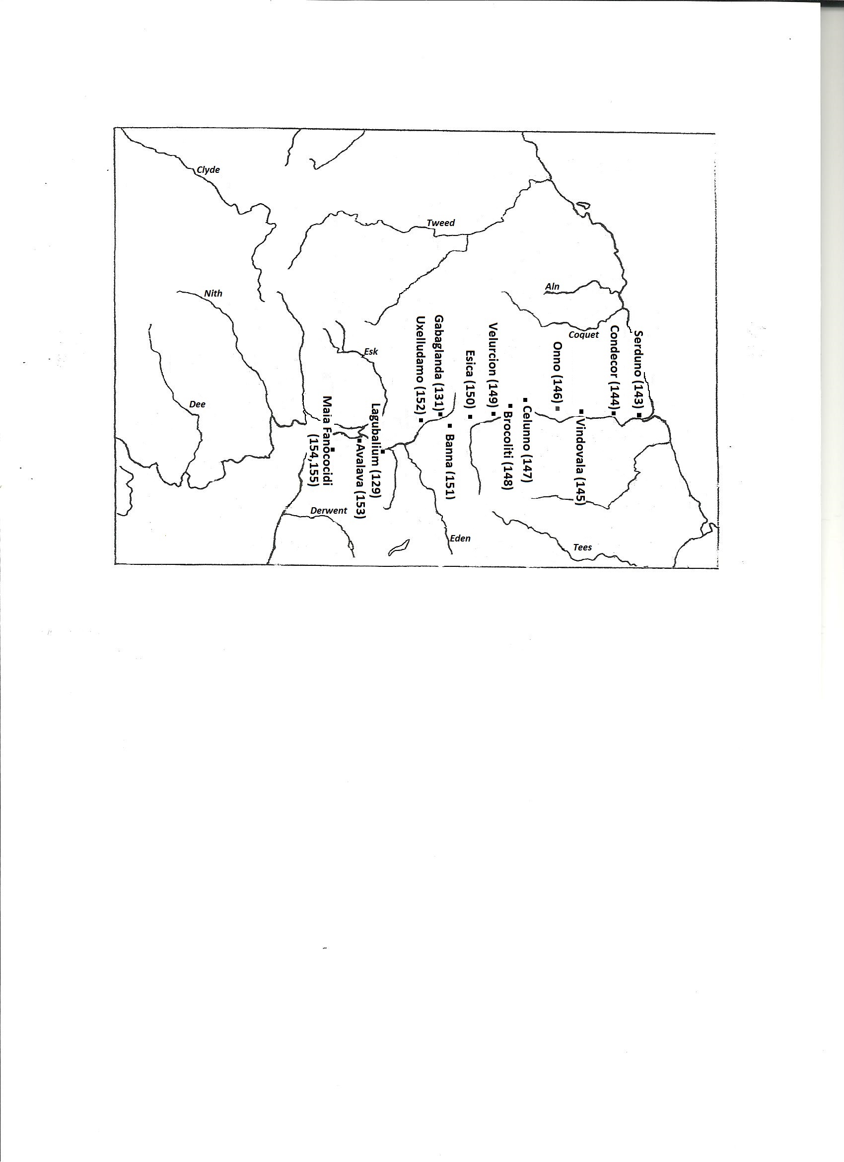
4 The map below shows the Trajanic frontier formed when the Romans withdrew their troops from Scotland. The numbers accompanying the names on the map are those provided by Richmond and Crawford. The identifications are as follows:
Serduno = Wallsend
Condecor = Benwell
Vindovala = Rudchester
Onno = Halton
Celunno = Chesters on the North Tyne
Brocoliti = Carrawburgh
Velurcion = Housesteads
Esica = Great Chesters
Banna = Throp
Gabaglanda = Birdoswald
Uxelludamo = Castlesteads
Lagubalium = Carlisle
Avalava = Burgh-by-Sands III
Maia Fanococidi = Kirkbride
| NB. The Trajanic frontier is also discussed in Chapter 20: Rome's frontiers in northern England. A few of the identifications discussed in the present chapter are there modified - this relates in particular to the section of the Trajanic frontier between the North Tyne and Throp, and the section west of Burgh-bv-Sands. |
[This page was last modified on 18 March 2021]